Area: 30.715 km²
Population: 4.007.860 (2000)
Traffic Code: 06
Population: 4.007.860 (2000)
Traffic Code: 06
 The history of Ankara and its surroundings stretches back to the Hatti civilisation of the Bronze Age. Two thousand years before the Jesus, the Hittites become the dominant power of the region, and were then followed by the Phyrgians, Lydians and Persians. In the 3rd Century BC, a Celtic race known as the Galatians made Ankara their capital city. The name Ankara comes from the word 'Ancyra', which means 'anchor.'
Ankara gained prominence under the leadership of Ataturk during the national resistence which followed World War I. It was declared the capital of the new Turkish Republic on October 13th 1923 when the National War of Independence freed Turkey from foreign occupation.
Occupying one of the most prominent parts of the city is Anitkabir, the magnificent mausoleum constructed to commemorate Atatürk. This structure, which was completed in 1953, is a synthesis of antique and modern architectural themes, and proves the elegance and strength of Turkish architecture.
The oldest parts of the city surround the Castle. The Alaaddin Mosque found inside its walls is still one of the best examples of Selcuk art and wood craftsmanship, in spite of the fact that it was restored by the Ottomans. The area has experienced a rejuvenation with the restoration of many interesting old Turkish houses, and the opening a several art galleries and fine restaurants which feature examples of traditional Turkish cuisine. Near the gate of the castle is the Museum of Anatolian Civilizations, which is a beautifully restored portion of the old bazaar. It contains priceless artifacts belonging to the Paleolithic and Neolithic eras as well as the Hatti, Hittite, Phrygian, Urartu and Roman civilizations.
Ankara has a vibrant cultural and artistic life with many select ballet, theatre, opera and folk dance performances. The city's Philharmonic Orchestra, which always plays to a packed house, is especially famous.
Districts
Altindag
Altindag
Altindag is 1 km from the city centre and has been occupied from prehistoric times. An important centre during the Selçuk and Ottoman periods, the city has many important sites of interest to visitors. Among them are the Ankara Castle, the Temple of Augustus, the pillar of Julian, the Roman Baths, the Republic memorial, the Museum of Anatolian Civilizations, the State Museum of Painting and Sculpture, the Museum of Ethnography, the War of Independence Museum and the Museum of the Republic. Also in this district are the tombs of Karacabey, Ahi Serafettin, Haci Bayram Veli Efendi, Karyagdi, Gulbaba and Izzettin Baba and the Haci Bayram, Aslanhane, Ahi Elvan, Alaaddin, Zincirli, and Kursunlu Mosques.
Cankaya
Cankaya
It is one of the most important districts in Ankara, with large area contains many places of interest. The Ataturk Orman Ciftligi, Eymir Lake, Elmadag Ski Facilities, Ahlatlibel Sport and Entertainment Centre are all within this area.
The huge list of primary tourist attractions includes: Anitkabir, the Ataturk Museum, the Ataturk Memorial (Zafer Aniti-Sihhiye), the MTA Natural History Museum, the Security Memorial, the Ethnographic Ataturk Memorial, the Natural History Museum, the Archeology Museum of Middle East Technical University, the State Painting and Statue Exhibit, Memorial Park, the Botanical Garden, Abdi Ipekci Park, Guven Park, Kurtulus Park, Kugulu (Swan) Park, the National Sovereignty Park, Ahmet Arif Park and sport facilities such as the Municipal Ice Skating rinks and the Indoor Pool at 100 Yil. There is also a Toy Museum (Cebeci-Ankara University Education Faculty), the Hittite Memorial, Atakule and the Turkish National Parliament buildings.
Kecioren
Kecioren is one of Ankara's central districts, and host to the world's biggest meteorology centre, as well as several departments of Ankara University, the Ataturk Sanatorium and the Gulhane Military Medical Academy. Also the Old is Ankara Agricultural School, used by Mustafa Kemal Ataturk as a military headquarters during the War of Independence, and is now a museum.
Yenimahalle
Yenimahalle
Yenimahalle is within the city and has attractions which reflect the rich history of the area. Its highlight is the Akkopru Bridge, built in 1222 by the Selcuk ruler Ala'addin Keykubat along the old Bagdat Commercial road over Ankara Creek, which has four large arches and three small.
Outside the city
Akyurt
Outside the city
Akyurt
Akyurt is 33 km from the city centre, and was occupied from the Early Bronze Age until the 14th century. A large tumulus 15 meters high and 200-300 meters in diameter was found 1 km northeast of the village of Balikhisar, which is a settlement from the 3rd millenium BC, and belongs to the Early Bronze Age.
Ayas
Ayas
This area, located 58 km from Ankara, is famous for its thermal springs. The radioactive waters of the Karakaya thermal springs and the mineral drinking water, 23 km west of Ayas, are known to be beneficial for those in poor health. The vineyards at Karadere, Ova, Ariklari and Kirazdibi are some of the district's natural resources.
Bala
Bala
The forest at Beynam National Park, 35 km from Bala on the district border, is an important recreation spot for city residents of Ankara, as well as the locals of Bala.
Beypazari
Beypazari
Located 99 km from Ankara, Beypazari's history goes back to the Hittites and Phyrgians. Beypazari and its surroundings have been controlled by the Galatians, Romans, Selcuks and Ottomans, and at one time was an episcopal centre. From historical artifacts and ancient maps, we know that its original name of Lagania was later changed to Anastasiopolis.
This charming district is famous for its historical houses, silver craftsmen and for its carrots. Within the district are many places of interest, including the Bogazkesen tomb, Suluhan, the Old Baths, the Sultan Ala'addin Mosque, the Aksemseddin Mosque, the Kursunlu Mosque, the Rustem Pasa Baths, the tomb of Gazi Gunduzalp (Hirkatepe), Kara Davut's Tomb (Kuyumcutekke) and the tomb of Karaca Ahmet.
The Tekke Highlands
The Egriova highlands, 10 km from the town, the lake and geological structures resembling 'fairy' chimneys around the village of Dereli, are some of the district's more interesting sites.
Camlidere
Camlidere
The district of Camlidere is located 108km northwest of Ankara. There is a mosque belonging to the Selcuk period in the nearby town of Pecenek. It is possible to come across the remains of graves and settlements from the Byzantine Era as well.
Cubuk
Cubuk
Cubuk is 39 km away from Ankara's city centre. The ruined castle at Aktepe and the Carved Rock (Oyulu Kaya) grave in the village of Karadana are remains of Hittite settlement. Later the area would be ruled by the Phrygians, Galatians, Persians, Romans, Byzantines and Selcuks respectively, and it was also area of some importance during the Ottoman Empire. The forest around Cubuk Dam and Lake Karagol are important recreation spots.
Elmadag
Elmadag
The Phrygians, Lydians, Persians and later Romans all ruled in the vicinity of Elmadag, located 41km from the city centre. The motifs and styles of the local hand-woven carpets, rugs, and various bags stretch all the way back to the Selcuk era. Carpet-making still happens in the villages of Tekke and Akcaali, while rugs and handwoven bags still preserve their cultural roots in the villages of Akcaali, Deliler, Hasanoglan, Karacahasan and Kayadibi.
Etimesgut
Etimesgut
The district of Etimesgut is 20 km away from Ankara center. Both the Phrygians and Hittites are known to have had settlements in this area. This area was settled mostly by Turks immigrated from western Trakya after the declaration of the independent Turkish Republic.
The historical Gazi Train Station and the Etimesgut Train Station, which was used by Ataturk on his travels to and from Istanbul, are both interesting sites. Ahi Mes'ud and Ahi Elvan, both great important people, named this district and Ahi Elvan's Tomb is found in the courtyard of the Elvankoy Mosque.
Evren
The history of this area, situated 178 km from Ankara, dates right back to the Hittite Period. Within the district along the Evren-Sariyahsi road, about 2km from Evren, is a tumulus, at which have been found ceramic artifacts dating back to the first millenium AD. Sigircik Castle, 2km southwest of Catalpinar village, belongs to the late Byzantine and Ottoman period.
Golbasi
Golbasi
Situated 20 km from Ankara, Golbasi and the surrounding area is important to Ankara in terms of recreation, summer getaway and tourism, as well as hosting important industries. Mogan and Eymir lakes with their natural beauty, clean fresh air and fishing make the area appealing to tourists and locals.
The villages in this area all have a fascinating historical background, with many sites worth seeing. For example: the tumuluses and artifacts found in the villages of Selametli, Gokcehoyuk and Bezirhane; the Roman burial sites and columns in the village of Taspinar; the Byzantine coins and artifacts found in Karaoglan; and the remains of churches belonging to the early Christian period in the villages of Yurtbeyi and Karaoglan.
Gudul
Located 89 km northwest of the Ankara, Gudul's history dates back to 3500-3000 BC. Huge caves found along Kirmir Creek, which flows through the district, have yielded evidence of Hittite settlement.
Haymana
Haymana
Haymana's thermal springs, 73 km from Ankara, are world-famous and were used even as far back as the Hittites. After the Hittites, the thermal spring facilities were repaired during the Roman era; and a town, whose ruins can still be seen, was founded 1.5 km east of Haymana and eventually became a therapy centre.
Kalecik
Kalecik
Situated 71 km from Ankara, Kalecik is believed to have first been inhabited in the early Chalcolithic Period between 3500-4000 BC. Notable historic sites in the district include the Hasbey, Saray and Tabakhane Mosques, the Tombs of Kazancibaba and Alisoglu, the Develioglu Bridge spanning the Kizilirmak River and Kalecik Castle.
Kazan It is not exactly known when Kazan was first established which is 45km from the city centre. Excavations have uncovered a number of historical artifacts demonstrating that the area has been used by number of different civilizations for settlement.
Kizilcahamam
Kazan It is not exactly known when Kazan was first established which is 45km from the city centre. Excavations have uncovered a number of historical artifacts demonstrating that the area has been used by number of different civilizations for settlement.
Kizilcahamam
Situated 83 km from Ankara, Kizilcahamam is the most heavily forested town in the province. The Sey Hamami thermal springs, 16km from Kizilcahamam, have rich mineral waters which are among the most important thermal springs in the country.
Nallihan
Nallihan
Nallihan's history is similar to that of the surrounding cities. The county seat, Nallihan, 161 km from Ankara, was established in 1599 when Vizier Nasuhpasa had a han built there - hence the name. The roof of this 3000 sq. meter han is in poor repair, and the mosque and a Turkish bath date back to the same time. The Uluhan mosque in Uluhan (Kostebek) village was constructed in the 17th century, and is a valuable historical structure.
Polatli
Polatli
Polatli, 78km from Ankara, was established around 3000 BC but its centre then Gordion and the surrounding area, which was the largest Phrygian city in the world. Gordion was ruled in succession by the Hittites, Phrygians, Persians, Romans and Byzantines, and was added to the Ottoman Empire in 1516 by Yavuz Sultan Selim.
The village of Yassihoyuk and the surrounding area, which lies 20 km northwest of the present-day Polatli, can truly to considered a birthplace of history. There are 86 tumuluses and royal burial sites in the area, as well as numerous artifacts from the city.
Sereflikochisar
The village of Yassihoyuk and the surrounding area, which lies 20 km northwest of the present-day Polatli, can truly to considered a birthplace of history. There are 86 tumuluses and royal burial sites in the area, as well as numerous artifacts from the city.
Sereflikochisar
148 km from Ankara, Sereflikochisar was first settled between 1400-1300 BC. In the Selcuk era there was a castle around the hill right next to the town, and a second castle on an even higher hill. The Salt Lake, which is the second largest lake in Turkey is also in this district. The Hirfanli Dam and lake found to the north provide irrigation for this arid region and there is fish farming as well. The Salt Lake, the Kursunlu Mosque, Kochisar Castle, and Parlasan Castle are all popular tourist destinations.
Where to Visit
Fortresses, Castles
|
Ankara Castle
The castle, which has guarded the city for centuries, is now a symbol of Ankara and its history is as old as the city itself. Although it is not exactly known when the castle was built, it is commonly believed to have been built by the Romans, then repaired and expanded by the Selcuks. It towers 110 meters above Bentdere Creek (Hatip Creek) which runs along its base.
There are two parts, an inner and an outer castle, with over 20 towers. The outer castle encloses the old city of Ankara within its heart-shaped walls. The four-level inner castle is made partly of Ankara stone and partly of stones gathered from other structures. The two large gates of the inner castle are called the Outer Gate and the Castle Gate. The towers within the castle vary between 14-16 metres in height. Today within the castle walls there are a number of Ottoman-style houses dating as far back as the 17th century. Kalecik Castle
Kalecik Castle is 78 km from Ankara on the road to Cankiri, and is a strong landmark from the modern town as it was founded on a cone-shaped hill. It is connected to the mountains in the southwest by a ridge and sits high above the plain formed by the Kizilirmak (Red River).
|
Ancient Civilizations, Ancient Cities
| ||||||||||||||||||||||
Gordion
The capital city of the Phrygian empire, the remains of the renowned city of Gordion are near the Ankara-Eskisehir highway at the confluence of the Sakarya and Porsuk rivers, 21 km northwest of Polatli, and 90 km from Ankara, in the village of Yassihoyuk. The history of Gordion goes back to 3000 BC (Early Bronze Age). It was an important settlement during the Assyrian and Hittite periods (1950 BC - 1180 BC) and, of course, the Phrygian era (900 BC - 620 BC), during which it was the capital city. It was named after King Gordios, the king who made it the capital. The famous knot made by King Gordios was cut in two by Alexander the Great in 333 BC, when he wintered in Gordion. The period of Alexander the Great (300 BC -100 BC) began in Gordion with his conquest. Following that, the area came under the control of the Romans (1st century BC to 4th century AD) and then the Selcuks (11th - 13th century AD). All of this occurred in the short space of 4000 years.
Ahlatlibel is located 14 km southwest of Ankara in the old Taspinar Village - Gavurkale - Haymana road. This Early Bronze Age site was an important settlement in Anatolia.
Bitik
The Bitik Mound is 42 km northwest of Ankara. The excavations have uncovered, from top to bottom, dwellings belonging to the Classic Age of the 5th century BC and going back to the Late Bronze Age. The Phrygian and Hittite dwellings are less important than the others. The artifacts at Bitik from the Late Bronze Age document the interest in Eastern and Western Anatolia.
Etiyokusu
Located 5 km north of Ankara on the banks of Cubuk Creek, it was excavated in 1937 by Professor Sevket Aziz Kansu under the auspices of the Turkish History Association. At the lowest level, tools belonging to the Late Stone Age were recovered. The level above that was similar to the culture of the Early Bronze, and that of nearby Ahlatlibel. At the very top level the remains of a large palace belonging to the different periods were unearthed.
Gavurkale
60 km southwest of Ankara, this area from the bed of Babayakup Creek, which flows right beside the hill, has been the site of continuous settlement. The hill was given the name Gavurkale (Infidel Castle) because of the broken down walls.
Gavurkale has drawn the attention of many. On the southern exposure of the steep cliffs is a relief of two gods walking, one behind the other, and across from them sits a goddess. There is a wall made of gigantic stone blocks surrounding this rocky outcrop. The stone reliefs here is just one example of these uniquely Hittite monuments found scattered throughout the country. Researchers have determined that this was an important walled city. First of all, it was thought to have been a Hittite worship centre, but later it was realised that the Phrygians settled here as well. The site was visited in 1930 by Ataturk himself. In the following years a number of surface investigations were conducted, and in 1998 new excavations were begun at Gavurkale by the Chair of the Museum of Anatolian Civilizations. Karalar
Karalar is a village about 60 km northwest of Ankara, and is important because of the fact that it witnessed continuous settlement during the Classic Age.
In the region known as Asarkaya, the architectural remains of a Celtic castle. Artifacts belonging to the Hellenistic Age have been found in the tumulus. Ancient coins discovered in the area indicate that there were commercial ties with Egypt and Syria. The Temple of Augustus
Situated adjacent to the Haci Bayram Mosque in Ulus, the temple was built in the 2nd century BC in honour of the Phrygian Goddess Men. The remains of the temple we see today are those of the temple built in honour of the Roman Emperor Augustus as a sign of fidelity by the King Pylamenes, the son of the Celtic ruler Amintos. During Byzantine times windows and other additions were made and it was turned into a church.
The perimeter is made up on four walls lined with columns, and around it are the column holders: 15 down the length of each side, six along the width, four in front of the temple door and two in the back. The only standing part of the temple is the door with its ornately carved posts. A copy of Emperor Augustus's last will and testament, the original of which is found in the Temple in Rome, enumerates his accomplishments and is located on the temple wall adjacent to the tomb. Detailed Information Julian's Column
This is located beside the pool between the financial directorate and the governor's building.. It is about 15m high, with a number of rings along its length, and has no inscriptions. It is said to have been set up in honour of Emperor Julian when he passed through Ankara (361-363 AD). It is known locally as the Belkis Minaret.
Roman Baths
Located on Cankiri Street between Ulus Square and Yildirim Bayazit Square, the baths sit on a platform about 2.5m above the street.
The baths dated back to Caracalla (212-217 AD). The Cankiri Street entrance to the Caracalla baths leads to a wrestling arena, which was covered with a portico surrounded with columns. On the one side of this courtyard are 32 columns with a total of 128 over the whole area. The actual baths are located immediately behind the wrestling arena. Besides the unusually large size of the structure, the baths have a very typical layout consisting of the Apoditerium (dressing area), the Frigidarium (cold-section), the Tepidarium (warm section) and the Caldarium (hot section).
Located in between Hisar and Pinar streets, the theatre was first discovered in 1982 and a salvage excavation began on March 15 1983 by the Museum Administration. The Museum of Anatolian Civilizations continued the excavations until 1986. What was uncovered, was the remains of a typical Roman theatre dating back to the 2nd century AD. In addition to a number of statues and statue pieces, all that remains are the foundations and walls of what was once a vaulted parados building, orchestra, amphitheatre and a stage.
Akkopru
This is, the oldest bridge in Ankara, crosses the Ankara Creek in front of Varlik Mahallesi. The Selcuk ruler Alaaddin Keykubat I it built in 1222 while Kizilbey was governor of Ankara.
Hoyuk (Tumulus)
Located with the boundaries of Turkhoyuk village, it consists mainly of marble columns and gravestones belonging to the Roman and Byzantine eras.
Kul Hoyuk is situated within the city limits of the town of Oyaca. It is reached by turning right about 50 km out on the Ankara-Haymana highway, towards the villages of Boyalik, Culuk, Calis and Durupinar. The tumulus is 1.5 km down this road on the right-hand side. The excavations are going on in this medium-sized tumulus, under the direction of the Museum of Anatolia Civilizations. The Hittite Cult Centre, 8 km to the west near Gavurkale, indicates that this was probably an important Hittite settlement. Besides the hidden cistern, built in the traditional style of grand monumental Hittite, there are the remains of huge foundations which can most likely be dated back to the Early Bronze Age and the beginning of the Hittite Empire. In light of the ceramic, bronze and other archeological finds, it is known that the area was inhabited about 5000 years ago. Karaoglan
Karaoglan is 25 km from Ankara along the road to Konya. The different strata in the tumulus have yielded remains from the following cultures: Chalcolithic, Early Bronze, Hittite, Phrygian, Hellenistic, Roman and Byzantine. This is one of the most important Hittite and Phrygian sites in the Ankara Golbasi region.
Bestepeler Tumulus was the first to be excavated, in 1926 by Makridi. In 1945, during the construction in the area, it became necessary to remove several of the tumuluses. Two of them were investigated and a number of clay jars and other tools belonging to the Phrygians were recovered. Experts concluded that these were contemporaries of the Phrygian graves at Gordion. It was at this time that they realised that the Phrygians placed their dead in graves dug on level ground, and then built a structure over the site with logs. The whole thing was then covered with dirt from the surrounding area to make a small hill. The dead were always buried with a number of gifts. ; Yumurtatepe (Demetevler) Tumulus is on the left hand side of the road at the Ciftlik - Demetevler intersection. It was excavated by the Museum of Anatolian Civilizations during the 1986 and 1987 excavation seasons, which identified the tumulus as belonging to the Early Bronze Age. It is a single structure, and a number of earthenware vessels were recovered. 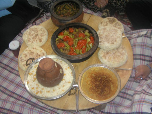
| ||||||||||||||||||||||

 |


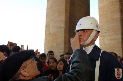
Ataturk soldiers crying for ...
No comments:
Post a Comment