 History of Gümüşhane, a transition region between Eastern Anatolian and Black Sea Region, reaches till to the 1500s B. C. It was founded on the historical trade road between Trabzon and Iran. It is a natural break point within fruit gardens and wild roses, between Trabzon and Erzurum. It is one of the richest cities of Turkey in connection with plateaus.
How to Get
Transportation to Gümüşhane is only maintaned via road. Coach station is in the city center.
Where to Visit
Ancient Cities
Sadak Settlement Ancient city, which is also known as Satala is 17 km. south east of Kelkit province. Today's Sadak Village was known with Satala name during ancient ages. It is thought that Sadak Village was the most important military camp of the ancient Roman Empire at east. This place is reigned by Hittites, Assyrians, Macedonians, Romans, Byzantines and Trabzon Comenoses. Today, ruins in Sadak Village are at the feet of a mountain rising like an amphitheater. There is a Nike relief on grave sites of Sadak Village.
Castles
It is known from the sources that approximately 35 castles with the aim of defending and watching Gümüşhane region are constructed. But most of these castles could not be reached today. Some of the castles are; Canca Castle, Akça Castle, Ardase Castle, Kodir Castle, Satala Castle, and Kov Castle.
Mosques, Mausoleums and Churches
Süleymaniye Mosque It is in the previous Gümüşhane settlement and in Süleymaniye District. It was constructed by Magnificent Suleyman, and repaired for several times till today.
Küçük Mosque It is in previous Gümüşhane settlement and within gardens behind Süleymaniye Mosque.
Küçük Mosque It is in previous Gümüşhane settlement and within gardens behind Süleymaniye Mosque.
Çit Village Mosque Balcony It is a mosque balcony in Çit Village of Torul Province. It is not an original balcony structure, and wooden adornment made for church. Its balcony is a good sample for wood craft. It is made with a deep craft, and an original wooden craft sample.
Mausoleums There are Pirahmet Mausoleum, Baba Çağırgan Mausoleum, Firdevs Hanım mausoleums in Gümüşhane.
Churches There are numerous churches within Gümüşhane. These are; Santa Çakallı Church, Santa Terzili Church, Hagios - Georgios Monastery Church, Pavrezi Chapel, Ayvalok Church, Çakırkaya (Kalur) Rock Church, Panagina (Mother Mary) Manastır Church, Vank Church, Mivaaras Church, Hagios Ioannas Manastır Church, Stephanus - Timios Stavroz Church, Satamoni Church (Yağlıdere Parti District).
National & Natural Parks
NATURE PARKS
Location: The Arbatel Lakes are 50km from Gumushane, 120km south of Trabzon, in the Black Sea region, and 5km from the village of Gulacar.
Transportation: The best public transport to the area is from Gulacar. Gumushane can easily be reached by road from Trabzon, Bayburt or Toral.
Highlights: The entire region of the park is filled with lakes and mountains, which forms a wonderful area for trekking. Karanlik Gol (Dark Lake) is the north-east foot of Artabelinbasi Peak, four lakes known as Besgoller, on the west of Sofraninbasi Peak, and three lakes known as Karagoller are at the foot of the eastern peak of Gavurdagi Mountain. The summers are hot and dry, and the winters cold and rainy.
The main trees in the forests are Scotch pine and fir, and there are many animals and birds in the area. The area around the lakes has very rich geologic and morphologic characteristics, especially with its rich collection of flora and fauna. The 5859 hectares were granted status of Natural Park in 1998, mainly to preserve the 18 glacier crater lakes.
Kıranı Saint Juniper
|
Characteristics: A juniper tree at the altitude of 2123 meters which is 700 years old, 4.80 meters tall, have a diameter of 1.32 meters and circumference length of 4.15 meters.
Foundation Date: 26.06.1995
Ali Ağa's Poplar
Place: Gümüşhane
Characteristics: Poplar tree which is 30 meters tall, have a diameter of 1.55 meters and circumference length of 4.85 meters.
Foundation Date: 26.06.1995
Characteristics: Poplar tree which is 30 meters tall, have a diameter of 1.55 meters and circumference length of 4.85 meters.
Foundation Date: 26.06.1995
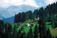
Highlands
Zigana Tourist Center-Zigana Highland
Transportation: After going through the Zigana tunnel 60 km out on the Gümüşhane - Trabzon road, you need to turn east on the gravel road and continue on 3.5 km. From the center of Trabzon to Zigana is 112 km on an asphalt road.
Description: The 2032 m. high Zigana Highland is also a ski center. Its infrastructure is completed.
Zigana is one of the few places in Turkey where someone can ski in the winter and do 'grass sledding' in the summer. It is a very interesting place caught between the sea climate on one side and the continental on the other.
Accessed by a 3 km path from Zigana Highland, Lake Lima (Saran) is definitely worth seeing. You may reach the lake by way of Kalkanlı with a rented car.
The road is asphalt for 11 km; the remaining 8 km is a dirt road. The village of Kalkanlı has electricity, running water, a post office and there is a small market, butcher, green grocer and teahouse open year-round.
Accommodation - Food and Drink: Because it is used as a ski center, it has every kind of lodging as well as shops to buy food and drink.
Şiran - Tomara Waterfall
Transportation: Fourteen km southwest of Şiran, the Tomara waterfall can be reached by a gravel road. The village of Seydibaba is only 2 km from the waterfall and there is a minibus service to this village.
Description: The waterfall formed by a powerful spring which spills over rocks and falls 8 m. is ice-cold. The pristine surroundings are covered with lush hazelnut, oak and hornbeam trees.
The untouched natural surrounding of Seydibaba Village which is full of orchards and vegetable gardens, makes a perfect campsite. The vitality and simplicity of nature beckons for you to sit and enjoy.
Accommodation - Food and Drink: There are no facilities in the vicinity of the waterfall. You need to bring your own camping gear if you intend to stay. Basic necessities can be purchased locally.
Altıntaşlar (Kalis) Highland
Transportation: In order to reah there you need to take the Gümüşhane - Torul road 15 km south and then turn towards Şiran. You will go through the villages of Hasköy and Gülaçar. The first 40 km is asphalt and the last 12 km a simple dirt road. The village can also be reached by turning west at the 40 km mark on the Gümüşhane - Şiran road and following the rushing waters of Altıntaşlar Creek with its scenic vistas.
Description: There is a small stream running through this village in which some infrastructure improvements have been made. There are numerous trout in the Altıntaşlar Creek and it is said that there used to be a gold mine nearby.
Six kilometers away in Altıntaşlar, there is a small market, butcher, teahouse and a restaurant.
Accommodation - Food and Drink: If you want to stay overnight in this pristine area, you need to bring your camping gear. Basic necessities can be obtained in nearby Altıntaşlar.
Çam Picnic
Transportation: After taking the Gümüşhane- Bayburt road for 2.5 km., turn south and follow the dirt road another 15 km. There is a minibus service to Çam Picnic from Gümüşhane.
Description: There is electricity and water as well as trash collection sites, a fountain, toilets and stone circles for lighting camp fires in the forest. The forest which is made up of mostly fir, spruce, alder and wild hazelnut trees is a popular recreation spot with the locals.
Accommodation - Food and Drink: Bring camping equipment as well as basic food stuffs.
Sports Activities
Gümüşhane has mysterious plateaus, which are hidden between forests and plentiful oxygen and dense forests. There are camping and caravan camping possibilities within most of these plateaus. Zigana, Taşköprü, Kazıkbeli, Kadırga, Artabel, Erikbeli plateaus are ready to submit all possibilities on these matters. The plateaus have appropriate routes of trekking.
Gümüşhane - Zigana
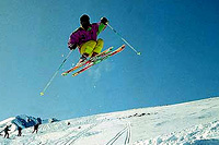 The Zigana Ski Centre is in the Black Sea Region, 40km north of Gumushane.
Arrival: Zigana is 60km south of Trabzon, the closest airport, and just 500m from the main road leading north of Gumushane. There is public and private transport from the ski centre to the city.
Geography: Covered mainly with forest, the ski runs are between altitudes of 1900-2500m, and covered with grass for most of the year. The season is between December and April, and there is an average snow depth of 1.5m.
Facilities: The ski centre has a lodge, a T-bar and baby-lift. The ski run is around 200m wide, with an average gradient of 20%.
Geography

History

What to Buy

No comments:
Post a Comment