The province is located at the east border of Türkiye, and a province that must be seen with mtyhical Mount Ağrı.
How to Get
Road Only connection with neighbour countries, surrounding provinces and counties can be occupied by roadway.
Air Way You can reach Iğdır by road way after arrival of Kars airport by plane
Where to Visit
Places to Visit
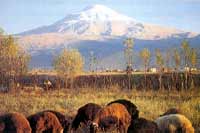
 Mount Ağrı Mount is highest top of Türkiye, and constitute border between İran and Iğdır. Height of mount is 5165 meter. It is an old volcanic mountain.
Harmandöven Caravanserai İt is on the old silk road in the Batum - Tebriz route of caravan roads, built by Şerafettin Ejder Bey, Emiri of Sürmari at 12th century in the Seljuklian Period.
Koçbaşı Tombs Koçbaşı tombs can found almost every graveyard in the Iğdır Plain. They remain from Karakoyunlu Period.
Aras River Around the Aras river, by the support and encouragement of government institutions of hostel, eating, drinking and entertaining can be built.
Museums
 Genocide Monument is at the surrounding way crossroads in Baharlı Quarter.
 Open hours to visit: 07:30 - 14:15
Geography
 Terrestrial climate dominant at Iğdır because of geographic situation. The tempeture is more above the region average and takes very little rain.
History
 Hurri's settle down at region in the year of 4000 BC. after them region take stage for different civilisations. Region get under control of Urartu, Saka, Sasani, Byzantine, Seljuklian, Mongols, Oguz, Karakoyunlular and Ottoman Empire until today.
Where to Stay
Tourism Facilities Data Base Updating Project is still in progress. Upon the end of the current process some of the shortcomings related to Tourism facilities and regarding information will be removed.
Where to Eat

A meal named Bozbaş that made from lamb shin is famous
Don't Leave Without
| - Mountaineering Mount Ağrı that famous with its myth's - Tasting meal named Bozbaş |
No comments:
Post a Comment