 Eskişehir was founded in 1000 BC by Frigs at the banks of the Porsuk River. The city is located at a major crossroad in Turkey. World wide famous historical personalities like Yunus Emre and Nasrettin Hoca (Hodja) was from Eskişehir. Eskişehir is also famous by meerschaum craftsmanship and hot spring waters which cures various diseases.
 Besides the cultural riches, Eskişehir is planning to become a tourism attraction center with its natural riches, food varieties and shopping possibilities.
How to Get
Highway The bus station is approximately 2 kilometers away from the city center. Reaching the bus station is possible via all public buses from every quarter of the city. The special services of bus companies are also available.
Railway Reaching Eskişehir via railroad is possible.
Where to Visit
|
Valley The ancient city is in the borders of Yazılıkaya Village of Han district which is 90 km. away from Eskişehir. At the executed excavations, foundations and structure ruins proving the existence of three different periods of Frig Kingdom, Lydia Kingdom and Persian Empire were discovered. On the other hand, the findings related to the existence of a city over an acropolis around the Midas Monument were determined.
The Midas (Yazılıkaya)(Written rock) It was founded on a rocky platform and mankind settled to this area in the Early Bronze Age and was the religious center of Phrygian civilization. The remnants of embossed designs on rocks produced by the Hittite culture with their own styles was observed in the ancient city. Yazılıkaya had developed as a city of Phrygian civilization after the Hittites, and 33 ruins related to the Phrygian culture like city walls, settlement areas, embossed designs on rocks, mausoleums carved in rocks, water cisterns, sacrificial altars, tombs carved in rocks, memorials with steps, niches and ancient roads. Although these ruins were corroded because of the natural conditions, they were able to withstand the destruction of nature and reach to modern days. Most of the Phrygian structures were destroyed by Romans and Byzantines because of religious matters, and rocky shelters and rock tombs were constructed instead of these structures. The Phrygian rock monuments were embroidered as the frontal side of a temple on the rock surface and were devoted to the mother goddess Cybele, who was the only deity of the Phrygian civilization. Lion was the sacred animal of the Phrygian religion.
At the forest covered part of the valley in the region located between the Çukurca Village and Kümbet Village, there are monuments, occult monuments, open air and nature shrines and various other ruins around 25.
Pessinus This is a city dedicated to the mother goddess Cybele inside the borders of Ballıhisar Village of Sivrihisar District. Pessinus, which is also known as the city of temples had preserved the importance and holiness during the period of Romans. The ruins of stadium, theatre, temple, water channel and remains of the necropolis belonging to the city are still standing. The archeological excavations had been in progress in the ancient city since 1967. The discovered art works obtained from the excavation are exhibited in the museum at Ballıhisar.
Doryleaum The tumulus is located at the northern neighborhood of the city and to the east of the Muttalip Village and it was determined that the tumulus had inhabited the periods of Hellenistic, Roman and Byzantine. The works belonging to the periods of Hellenistic, Roman and Byzantine discovered at the excavation at the tumulus and its skirts are exhibited in the Archeology Museum.
Karacaşehir This ancient city is located at the southwest of Karacaşehir Village which is 6 kilometers away from Eskişehir. This ancient city was initially constructed by the Romans and later by the Byzantine and was reinforced by Ottomans and is called as the Castle city. The defense walls of the city have totally collapsed in time and only small fragments of the towers at the east and west entrance gates are standing. The ruins of the headquarter buildings, cistern, streets and the houses are visible inside the castle.
Karacaşehir This ancient city is located at the southwest of Karacaşehir Village which is 6 kilometers away from Eskişehir. This ancient city was initially constructed by the Romans and later by the Byzantine and was reinforced by Ottomans and is called as the Castle city. The defense walls of the city have totally collapsed in time and only small fragments of the towers at the east and west entrance gates are standing. The ruins of the headquarter buildings, cistern, streets and the houses are visible inside the castle.
Midas Monument The monument is located at the northeast skirt of the Yazılıkaya platform, at the eastern side. This monument is called as Yazılıkaya and Midas Monument by various persons. The ancient city took its name from this monument. This monument is the major structure of the city and is the most magnificent of the rocky monuments of Phrygia. This monument is one of the most important and unique art works of the region and the world.
Külliye and Mausoleums
The most important mausoleums of Eskişehir are the Şeyh Şahabattin Mausoleum which is located at the west of the Kurşunlu Mosque and the Şeyh Edebalı Mausoleum which belong to the father - in -law of Osman Bey, the founder of the Ottoman Empire.
Yunus Emre Külliyesi and Mausoleum It is located in the Yunus Emre Borough (Sarıköy) of Eskişehir Mihalıcçık District. The Eskişehir - Ankara railway passes nearby. Yunus Emre is a bard who calls the nations of the world to love, unity and peace. The live philosophy of Yunus Emre was summarized by the words "gelin tanış olalım, işi kolay kılalım, sevelim sevilelim, bu dünya kimseye kalmaz." " come on, let us meet, lets facilitate the job, lets love and be loved, the world remains for no one" which was written as an epitaph.
Seyit Battal Külliyesi It is located at the eastern skirts of Üçler Hill at a height of 150 meters in Seyitgazi District. This külliye is constructed as a dedication to Seyyit Battal Gazi (1207 - 1209).
The Traditional Eskişehir House
The house of Nasrettin Hoca Nasrettin Hoca, who is the founder of the jokes which hold an important place in the world humor literature was born in Hurt Village of Sivrihisar District in 1208. The commemoration festivals and folk literature seminars in the name of Nasrettin Hoca have been arranged in Hortu Village in Sivrihisar District of Eskişehir every year.
National and Natural Parks
Place: Eskişehir
Characteristics: A 10.5 hectares area consist of smooth and plump Scots pines that are 200 - 400 years old and between the length of 38-45 meters.
Foundation Date: 03.11.2000
Characteristics: A 10.5 hectares area consist of smooth and plump Scots pines that are 200 - 400 years old and between the length of 38-45 meters.
Foundation Date: 03.11.2000
Ornithology Areas
Türkmenbaba Mount, Aliken, Balıkdamı, Sarıyar Dam and Hamam Mount Bird Areas are in Eskişehir.
Türkmenbaba Mountain
City: Kütahya, Eskişehir
Provinces: Eskişehir Merkez, Kütahya Merkez, Seyitgazi
Surface Area : 17500
Altitude : 1200 - 1826 m
Protection: partially
Bird Species: The biggest population of black vulture Kara akbaba (10 pairs) known in Turkey lives in the region. At the same time there are important breeding numbers of black stork kara leylek (5 pairs), lammergeıer sakallı akbaba (1 pair) and booted eagle küçük kartal (5 pairs).
Main Characteristics: forest, mountain
Aliken
City: Eskişehir
Provinces: Pairseler, Sivrihisar
Surface Area : 11500
Altitude : 875 - 909 m
Protection: N/A
Bird Species: It is estimated that there are approximately 20 breeding pairs of great bustard toy in the area., the maximum number of individuals recorded is 45.
Main Characteristics: plateau, agricultural area
Balıkdamı
City: Eskişehir
Provinces: Sivrihisar
Surface Area : 1470
Altitude: 799 m
Protection: Yes
Bird Species: It is important for the populations of Montagu’s Harrier çayır delicesi (15 pairs) and Lesser Kestrel küçük kerkenez (10 pairs in Ahiler) as well as migrant storks (max.17.915). The region has importance during migration for water birds, including ruddy shelduck angıt (max. 302).
Main Characteristics: sweet water lake, swamp
Hamam Mountain
City: Eskişehir
Provinces: Mihalıççık
Surface Area : 14000
Altitude : 900 - 1574 m
Protection: N/A
Bird Species: Important for black vulture kara akbaba (5 pairs) and booted eagle küçük kartal (1 pair).
Main Characteristics: forest, mountain
City: Eskişehir
Provinces: Mihalıççık
Surface Area : 14000
Altitude : 900 - 1574 m
Protection: N/A
Bird Species: Important for black vulture kara akbaba (5 pairs) and booted eagle küçük kartal (1 pair).
Main Characteristics: forest, mountain
Caves
Caves of Eskişehir
Sarıkaya Cave
Location: Eskişehir, Mihalıççık District, Yalınkaya Village
Following the branch of Eskişehir Mihalıççık road in the direction of Büyüdüz - Sasa - Yalınkaya, Yalımkaya village is reached. To reach the cave, an hour of walking inside the deep canyon of Domya creek from Yalınkaya is necessary.
Properties: The total length of the cave is 665 meters and it has two main entrances. The cave is formed of three layers connected to each other. The floor of the cave contains sand, pebbles and rubbles and because of the humidity of the lower layer, there are numerous damlataş formations. These damlataş are at the shapes of stalactite, stalagmite , pillar, wall and drapery damlataşı and their formation is still in process. The damlataş pools are mostly in colors of black and brown. The upper layers contains fossils. These layers are poor of damlataş.
The atmosphere of the cave is cold and moistured. The upper layer has a temperature of 13ºC, 80 percent humidity, the lower layer has temperature of 10ºC ve90 percent humidity.
The cave contains Flintstones chipping, ceramic and brick pieces and human bones displaying that this cave was in use at the prehistoric and historic periods.
Yelinüstü Cave
Location: Eskişehir, Günyüzü District, Kayakent Sub district
The cave is located at the southeast part of the Sivrihisar Mountain extending between the Sivrihisar - Günyüzü road and Sakarya river. Reaching to the Kayakent sub district is possible via Ankara-Eskişehir or Ankara -Polatlı - Yunak highways. The cave is close to the Kayakent Subdistrict.
Properties: The total length of the cave is 420 meters and the depth of the final point in respect to the cave entrance is at -90 meters. The second chamber is reached via a narrow gallery having small downward descends branching from the right side of the cave entrance. There are different damlataş formations inside the chamber covered with large blocks. This saloon gives opening into two different saloons having the same formations.
The cave is mostly dry except the periods at which water drips from the ceiling. There are cisterns and pools constructed to collect these dripping water. The average temperature inside the cave is 20ºC and the humidity is 70 percent.
This cave displays similar properties with Yelini Cave and remains and shapes showing that this cave had been used by humans for a long time are also present in this cave.
Yelini Cave
Location: Eskişehir, Günyüzü District, Kayakent Subdistrict
This cave is located at the south of the Yelinüstü Cave and is at the southeast of Sivrihisar Mountains extending between Sivrihisar and Günyüzü Sakurada river. Reaching to the cave is possible via Ankara-Eskişehir or Ankara - Polatlı -Yunak highways.
Properties: The total length of the cave is 271 meters and the deepest point in respect to the cave entrance is at -26 meters. The cave had been divided into many saloons and chambers by the large blocks fallen from the ceiling and damlataş and is covered with extremely beautiful looking damlataş.
Generally, the temperature inside the cave decreases while humidity increases as advanced from entrance to the end. The cave has temperature of 25.5ºC and humidity of 45 percent at the entrance and temperature of 16.1ºC ve79.5 percent of humidity at the final saloon.
This cave displays similar properties with Yelinüstü Cave and remains and shapes showing that this cave had been used by humans for a long time are also present in this cave. In front side of the cave and at the slopes and fields, flint stones, chipping, axes and spearheads were found. At the entrance part, various tools, bones, pottery pieces were found. There are cisterns and pools with depths exceeding 2 meters made of bricks were present at the saloon.
Thermal Springs
Sarıcakaya - Sakar Thermal Resort
Location: The resort is around 33km north of Eskisehir, southeast of Bursa in Central Anatolia.
Transport: Eskisehir is easily accessible by road or air, and the Sakar resort is off the road to Mihalgazi.
Water temperature: 56°C
pH value: 7.6
Physical and chemical properties: Hyperthermal, hypertonic mineral waters. Bicarbonate, sodium, magnesium, calcium, sulphate, nitrate.
Recommended: Applications Bathing
Helps to heal: Diabetes, obesity, gout, certain blood disorders, excess sugar and fat, prevents kidney stones.
Accommodation: Municipality Facilities - 400 beds. Aytac Tourist Facilities - 40 beds.
Air Sports
Paragliding
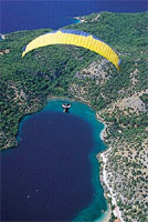 Paragliding sport is to take off by means of running from a high hill instead of plane with a parachute similar to free style jumping parachute on the first look. Parachute, which is lied on a inclined and high hill, is filled with air with the running of pilot and take off with pilot. Periods of the flights can continue for kilometers / hours in connection with the experience of pilot and performance of the materials used. Although it can be for single person, there is two persons ( tandem ) wings.
Paragliding , whose first trial had been made in 1940s, and numerously modified till today. There were lots of structural improvements which has increased the flight period and security of perform. First paragliding was similar to free style diving parachute. It had turned into an aerophyl structure which has high raising power instead of its pressure enduring characteristic with changing in time. Paragliding parachute wing structure had reached to its appropriate shape for easy to take off, slowly descending ratio and good flying performance, beginning from 1980s.
Paragliding Sport in our country had been recognized with the discover by foreign pilots of Mount Baba in Fethiye, Ölüdeniz (Blue Lagoon) region at the beginning of 1990s, and actively started in university clubs initially. Being the most economical aerial vessel and being inside the natural sports, maintained it to be performed by a massive number of people today. Paragliding Parachute Sport, which does not require a special skill or much effort basically, is very easy and enjoying to do after a standard training. Paragliding training are organized by THK, university clubs and private clubs.
Some of the Flight Zones
ÖLÜDENİZ - BABADAĞ
Location: Mount Baba, which is in the province territory of Fethiye of Muğla city, is 7 km inside from the coastal line. It rises just after the Ölüdeniz (Blue Lagoon) beach and faces just towards to south. You can reach to take off runway via a 45 minutes from Ölüdeniz stabilize but nearly smooth road.
Flight Season: Secure flights can be performed between April and October.
Regional Characteristics: Ölüdeniz, which is the first place where paragliding is performed in Turkey, has a world - wide fame. Its unique nature, sun and sea is enchanting thousands of national and foreign tourists every year, and has a structure appropriate for all kinds of outdoor activity. There is no transportation, accommodation and nutrition problems within the developed touristic center, region. Yacht tours are also drawing attention in the area. Mount Baba is preferred as trekking and camping area during summer and winter.
Take Off Runways: There are total of three runways in Mount Baba. 1700 meters high in south runway is appropriate to take off. 1800 meters high north runway is a little bit small and upright. Take off area of the 1900 meters high north peek runway is very comfortable. As 1700 meters high runway is taking the south wind just from the opposite side during the most part of the day, generally take off is made from here. Approximately 20 wings can be lied on very wide runway at the same time.
Landing Runway: Belcekız beach at the coast of Ölüdeniz, is a long and very comfortable and secure landing runway with its width.
Meteorological Characteristics: During summer season, the weather is stable. Sometimes during morning hours a north wind comes and take off is made from north runways into the valley. The South runway faces a south wind, between 5 - 20 km. during most of the day hours.
Things that should be considered: Especially during the beginning and end of the season, climate change months weather can change rapidly and cloud can cover the take off area. On south runway, during the period till to the midday west wind coming from the west end of the mount, can create a false south wind and mislead.
DENIZLI - PAMUKKALE
Location: Pamukkale is at the feet of Mount Çökelen which is 21 km away from Denizli. As it is a touristik region all kinds of transportation is available to the region.
Flight Season: Flight can be made during all seasons with its warm climate.
Regional advantages: An ancient settlement region, Pamukkale is one of the most important tourism centers of our country where thousands of tourists are coming every year with its ancient ruins and travertine formed with the settlement of lime water.
There are two hills to take off:
Training Hill
Meteorological Characteristics: After the sun rise, the wind which can be sensed at south - west direction blows mild till to the noon hours. The wind which increases its speed during noon hours slides to the west and nearly fully stops during sun set.
Take Off Runway: As 70 m high hill is low it is preferred for amateur flights. Due to the warm impacts of the underground waters in all of the region wind changes sensed within the region is not sensed here. By means of regular winds secure flights can be made during the year.
Landing Runway: Flights from the slope is ended at the plains of the region. Landing points are very secure due to not holding a handicap.
Things that should be considered: Though turbulence formed with the speeding up wind during the noon hours of the months when summer hot is lived most densely should be considered.
Dynamite Warehouse
Meteorological Characteristics: The hill, which is reign by western winds is especially appropriate for flight during morning hours. Strong thermal formations which begin around noon are maintaining long flights for experienced pilots.
Take Off Runway: Flight runway, which took its name from a former dynamite warehouse at the peek of 300 meters high. Slope which has a wide area to take off of two parachutes together easily, is at a point from where you can see all beauties of Pamukkale.
Landing Runway: Although you can land to the area at the end of flight track, you can also land securely to the helicopter runway at the entrance of travertine.
Things that should be considered: Turbulence formed during noon hours of summer months require maximum control and consideration during flights. You can face with turbulence at the end of take off runway during hard winds. Cross blowing wind causes asymmetrical close at parachute just after take off. Also ending of hill with high slope requires a very quick run for a successful take off.
ANKARA - GÖLBAŞI
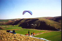 Location: Transportation to Gölbaşı region, which is 27 km. away from Ankara city center can be easily maintained from city center.
Regional Characteristics: Due to closeness to Ankara it is possible to benefit from all activities and possibilities within the city. It is the region where aerial clubs of universities in Ankara are training Paragliding . Gölbaşı, is also a promenade place which draw attention of Ankara residents who want get away from city life goes for weekends.
Take Off Runway: Training hill which faces to a wide plain is very appropriate for hillside parachute training due its appropriate altitude and facing wind from all aspects.
BOLU - ABANT
Location: Abant Mountains, is 34 km. in south of the Bolu city center. Asphalt 25 km. long Abant Lake road can be used for reaching. Road transport to Bolu, which is on the Ankara - Istanbul highway passing is very easy. For reaching Abant Lake minibuses departing from city center can be used.
Regional Characteristics: Dense rain forests surrounded Bolu city is appropriate for all kinds of tourism activity. Abant Lake, whose environment has a rich plant cover, is drawing attention as a picnic and resort place during summers and an appropriate place for winter sports during winter. Abant Lake surrounding accommodation and nutrition possibilities can be benefited.
Take Off Runway: Abant Mountains have more than one take off runways appropriate for hillside parachute. Generally it is performed on the hills surrounding Örencik Plateau, near to Abant Lake, wide, plain and fully covered with grass.
EGIRDIR
Location: There are roads and railway transportation in Eğirdir, which is 60 km. away from Isparta. Local bus firms of Isparta are passing from Egirdir.
Regional Characteristics: Egirdir which is appropriate for various tourism activities with Eğirdir lake and island, has very appropriate hills for paragliding parachute. Süleyman Demirel University Aerial Club is performing training flights on these hills.
KAYSERI
Location: Ali Mountain on the territories of city in Kayseri, is 15 min. Away from city center. It can be driven up carefully. Or when you get off the bus at Ali Mountain plate with getting on to a bus, you can reach to the hill within 45 minutes by foot.
Regional Characteristics: World wide famous Cappadocia present, Kayseri is welcoming to thousands of tourists each year. Kayseri is serving possibilities to the other sportive tourism types such as skiing and cycling besides paragliding with its appropriate geography. Civil Aviation VIHE, is organizing training flights to Mount Ali.
Take Off Runway: It has an altitude difference of 600 to 750, and there are two take off runways of which one is appropriate to south winds and other one is north. Steep and smooth inclination of the hill is appropriate for hours of paragliding, but you should be careful in weathers with turbulence.
Landing Runways: There are easily landing areas in front of the hill.
ESKIŞEHIR / İnönü
There are facilities of Turkish Aviation Organization within İnönü Province which is 15 km west of Eskişehir. North facing slopes of the province, are establishing very appropriate flight conditions with especially north winds during summer months. Courses organized by Turkish Aviation Organization are performed here.
ANTALYA / Aksu
Hill in Aksu province of Antalya is used as training hill by Akdeniz University, Avaiation Club. When you turn Perge ruins from Aksu turn of Antalya - Alanya road, and go for a 10 - 15 km. without entering Perge 40 - 50 m. high training hill is reached. Irrigation channel should be considered during flight.
Physical Conditions for Paragliding
For paragliding lower age limit is 16 and upper limit is 55. You can be flexible for upper age limit according to health condition. Kilo limit is minimum 40 kg, and maximum 130. Epilepsy, asthma, heart, waist and knee disordered people can not participate to hillside parachute training. For participation to hillside parachute a form declaring that health conditions are appropriate is filled.
Parachute Types
Parachutes (wings) have various sizes and types according to weight of the pilot and flight type. Parachute used by light weighted pilot, is smaller in size than heavy pilot uses. There are 5 types of parachutes showing different performances according to the training taken and experience.
Wing Structure
Paragliding can be investigated at 4 parts composed of Canopy (Dome), hook and break ropes, supporting columns and Harness (equipment).
Canopy It is made up of texture with no air transparency which will maintain parachute to remain in the air with supplying air pressure in the parachute. Canopies, is composed of approximately 40 - 60 cells according to the weight of the pilot and flight type, and these cells are connected to each other with valves for maintaining air pressure.
Hook and break ropes Ropes made up of a very resistant and light material are moderately to the canopy in order to support the pilot. Ropes in front of the canopy are collected on front columns and rear ones are collected on rear columns. Break ropes are different colored and they pass through a ring (they won't hurl even if pilot leaves them free) and place into the final column.
Supporting Columns Supporting columns, are connecting dome ropes to equipment. They maintain suitable holding places to pilot during take off. They give possibility to use different harness usage beyond easing take off. While there are accelerators known as speed system on less developed hillside parachutes, it is fixed to harness columns on some of them.
Harness (Equipment) It is part where pilot will sit. It is basically composed of hooks passing through feet and arms for equipment of pilot. Its structure can vary according to the used material and additional equipment. There are cross columns on some harnesses. These have a structure of directly transiting body movement of pilot to upper part for more securing the dome. There are speed system connections, back protector, air bag, spare parachute division like advantages of developed harnesses. All harnesses can be modified according to the body structure of the pilot.
Meteorological Information
For performing air sports securely appropriate weather conditions are very important. Basic meteorological information is required especially paragliding Movement of the wind and shapes of the clouds are the factors initially signing for flight. Other two factors are turbulence and thermal.
Turbulence They are vertical aerial movements. Turbulences; are faced during 5 km/h exceeding impact movements, specific geographic regions, with a wind backward coming to a steep hill, in thermal entrances and exits and front regions.
Thermal It is formed with the rise of warm air mass. This air mass composes flight hindering clouds with cooling, and this is also causes hard turbulence. Thermal is more formed especially in rocky regions, asphalt areas, forest region, water region (river, lake, sea ...) and agricultural areas.
ÖLÜDENİZ - BABADAĞ
Location: Mount Baba, which is in the province territory of Fethiye of Muğla city, is 7 km inside from the coastal line. It rises just after the Ölüdeniz (Blue Lagoon) beach and faces just towards to south. You can reach to take off runway via a 45 minutes from Ölüdeniz stabilize but nearly smooth road.
Flight Season: Secure flights can be performed between April and October.
Regional Characteristics: Ölüdeniz, which is the first place where paragliding is performed in Turkey, has a world - wide fame. Its unique nature, sun and sea is enchanting thousands of national and foreign tourists every year, and has a structure appropriate for all kinds of outdoor activity. There is no transportation, accommodation and nutrition problems within the developed touristic center, region. Yacht tours are also drawing attention in the area. Mount Baba is preferred as trekking and camping area during summer and winter.
Take Off Runways: There are total of three runways in Mount Baba. 1700 meters high in south runway is appropriate to take off. 1800 meters high north runway is a little bit small and upright. Take off area of the 1900 meters high north peek runway is very comfortable. As 1700 meters high runway is taking the south wind just from the opposite side during the most part of the day, generally take off is made from here. Approximately 20 wings can be lied on very wide runway at the same time.
Landing Runway: Belcekız beach at the coast of Ölüdeniz, is a long and very comfortable and secure landing runway with its width.
Meteorological Characteristics: During summer season, the weather is stable. Sometimes during morning hours a north wind comes and take off is made from north runways into the valley. The South runway faces a south wind, between 5 - 20 km. during most of the day hours.
Things that should be considered: Especially during the beginning and end of the season, climate change months weather can change rapidly and cloud can cover the take off area. On south runway, during the period till to the midday west wind coming from the west end of the mount, can create a false south wind and mislead.
DENIZLI - PAMUKKALE
Location: Pamukkale is at the feet of Mount Çökelen which is 21 km away from Denizli. As it is a touristik region all kinds of transportation is available to the region.
Flight Season: Flight can be made during all seasons with its warm climate.
Regional advantages: An ancient settlement region, Pamukkale is one of the most important tourism centers of our country where thousands of tourists are coming every year with its ancient ruins and travertine formed with the settlement of lime water.
There are two hills to take off:
Training Hill
Meteorological Characteristics: After the sun rise, the wind which can be sensed at south - west direction blows mild till to the noon hours. The wind which increases its speed during noon hours slides to the west and nearly fully stops during sun set.
Take Off Runway: As 70 m high hill is low it is preferred for amateur flights. Due to the warm impacts of the underground waters in all of the region wind changes sensed within the region is not sensed here. By means of regular winds secure flights can be made during the year.
Landing Runway: Flights from the slope is ended at the plains of the region. Landing points are very secure due to not holding a handicap.
Things that should be considered: Though turbulence formed with the speeding up wind during the noon hours of the months when summer hot is lived most densely should be considered.
Dynamite Warehouse
Meteorological Characteristics: The hill, which is reign by western winds is especially appropriate for flight during morning hours. Strong thermal formations which begin around noon are maintaining long flights for experienced pilots.
Take Off Runway: Flight runway, which took its name from a former dynamite warehouse at the peek of 300 meters high. Slope which has a wide area to take off of two parachutes together easily, is at a point from where you can see all beauties of Pamukkale.
Landing Runway: Although you can land to the area at the end of flight track, you can also land securely to the helicopter runway at the entrance of travertine.
Things that should be considered: Turbulence formed during noon hours of summer months require maximum control and consideration during flights. You can face with turbulence at the end of take off runway during hard winds. Cross blowing wind causes asymmetrical close at parachute just after take off. Also ending of hill with high slope requires a very quick run for a successful take off.
ANKARA - GÖLBAŞI
Location: Transportation to Gölbaşı region, which is 27 km. away from Ankara city center can be easily maintained from city center.Regional Characteristics: Due to closeness to Ankara it is possible to benefit from all activities and possibilities within the city. It is the region where aerial clubs of universities in Ankara are training Paragliding . Gölbaşı, is also a promenade place which draw attention of Ankara residents who want get away from city life goes for weekends.
Take Off Runway: Training hill which faces to a wide plain is very appropriate for hillside parachute training due its appropriate altitude and facing wind from all aspects.
BOLU - ABANT
Location: Abant Mountains, is 34 km. in south of the Bolu city center. Asphalt 25 km. long Abant Lake road can be used for reaching. Road transport to Bolu, which is on the Ankara - Istanbul highway passing is very easy. For reaching Abant Lake minibuses departing from city center can be used.
Regional Characteristics: Dense rain forests surrounded Bolu city is appropriate for all kinds of tourism activity. Abant Lake, whose environment has a rich plant cover, is drawing attention as a picnic and resort place during summers and an appropriate place for winter sports during winter. Abant Lake surrounding accommodation and nutrition possibilities can be benefited.
Take Off Runway: Abant Mountains have more than one take off runways appropriate for hillside parachute. Generally it is performed on the hills surrounding Örencik Plateau, near to Abant Lake, wide, plain and fully covered with grass.
EGIRDIR
Location: There are roads and railway transportation in Eğirdir, which is 60 km. away from Isparta. Local bus firms of Isparta are passing from Egirdir.
Regional Characteristics: Egirdir which is appropriate for various tourism activities with Eğirdir lake and island, has very appropriate hills for paragliding parachute. Süleyman Demirel University Aerial Club is performing training flights on these hills.
KAYSERI
Location: Ali Mountain on the territories of city in Kayseri, is 15 min. Away from city center. It can be driven up carefully. Or when you get off the bus at Ali Mountain plate with getting on to a bus, you can reach to the hill within 45 minutes by foot.
Regional Characteristics: World wide famous Cappadocia present, Kayseri is welcoming to thousands of tourists each year. Kayseri is serving possibilities to the other sportive tourism types such as skiing and cycling besides paragliding with its appropriate geography. Civil Aviation VIHE, is organizing training flights to Mount Ali.
Take Off Runway: It has an altitude difference of 600 to 750, and there are two take off runways of which one is appropriate to south winds and other one is north. Steep and smooth inclination of the hill is appropriate for hours of paragliding, but you should be careful in weathers with turbulence.
Landing Runways: There are easily landing areas in front of the hill.
ESKIŞEHIR / İnönü
There are facilities of Turkish Aviation Organization within İnönü Province which is 15 km west of Eskişehir. North facing slopes of the province, are establishing very appropriate flight conditions with especially north winds during summer months. Courses organized by Turkish Aviation Organization are performed here.
ANTALYA / Aksu
Hill in Aksu province of Antalya is used as training hill by Akdeniz University, Avaiation Club. When you turn Perge ruins from Aksu turn of Antalya - Alanya road, and go for a 10 - 15 km. without entering Perge 40 - 50 m. high training hill is reached. Irrigation channel should be considered during flight.
Physical Conditions for Paragliding
For paragliding lower age limit is 16 and upper limit is 55. You can be flexible for upper age limit according to health condition. Kilo limit is minimum 40 kg, and maximum 130. Epilepsy, asthma, heart, waist and knee disordered people can not participate to hillside parachute training. For participation to hillside parachute a form declaring that health conditions are appropriate is filled.
Parachute Types
Parachutes (wings) have various sizes and types according to weight of the pilot and flight type. Parachute used by light weighted pilot, is smaller in size than heavy pilot uses. There are 5 types of parachutes showing different performances according to the training taken and experience.
Wing Structure
Paragliding can be investigated at 4 parts composed of Canopy (Dome), hook and break ropes, supporting columns and Harness (equipment).
Canopy It is made up of texture with no air transparency which will maintain parachute to remain in the air with supplying air pressure in the parachute. Canopies, is composed of approximately 40 - 60 cells according to the weight of the pilot and flight type, and these cells are connected to each other with valves for maintaining air pressure.
Hook and break ropes Ropes made up of a very resistant and light material are moderately to the canopy in order to support the pilot. Ropes in front of the canopy are collected on front columns and rear ones are collected on rear columns. Break ropes are different colored and they pass through a ring (they won't hurl even if pilot leaves them free) and place into the final column.
Supporting Columns Supporting columns, are connecting dome ropes to equipment. They maintain suitable holding places to pilot during take off. They give possibility to use different harness usage beyond easing take off. While there are accelerators known as speed system on less developed hillside parachutes, it is fixed to harness columns on some of them.
Harness (Equipment) It is part where pilot will sit. It is basically composed of hooks passing through feet and arms for equipment of pilot. Its structure can vary according to the used material and additional equipment. There are cross columns on some harnesses. These have a structure of directly transiting body movement of pilot to upper part for more securing the dome. There are speed system connections, back protector, air bag, spare parachute division like advantages of developed harnesses. All harnesses can be modified according to the body structure of the pilot.
Meteorological Information
For performing air sports securely appropriate weather conditions are very important. Basic meteorological information is required especially paragliding Movement of the wind and shapes of the clouds are the factors initially signing for flight. Other two factors are turbulence and thermal.
Turbulence They are vertical aerial movements. Turbulences; are faced during 5 km/h exceeding impact movements, specific geographic regions, with a wind backward coming to a steep hill, in thermal entrances and exits and front regions.
Thermal It is formed with the rise of warm air mass. This air mass composes flight hindering clouds with cooling, and this is also causes hard turbulence. Thermal is more formed especially in rocky regions, asphalt areas, forest region, water region (river, lake, sea ...) and agricultural areas.
In this camp of Turkish Air Institution Training Center, every kind of air sports could be executed in the world standards accompanied by the instructors and teachers.
Geography
 As Eskişehir is located in the Central Anatolian Region, the dominant climate is terrestrial climate. The summer seasons passes hot and dry and the winter seasons passes cold and precipitant.
History
 The first settlement in Eskişehir (Doryleaum) is based on the date 3500 B.C. The city had been under the reign of Hittites, Phrygians, Persians, Romans, Byzantine , Seljuks and Ottomans.
Where to Eat
Göceli Tarhana (soup with dried yogurt), harşıl, çerkez sofrası (Circadian meal), çiğ börek (raw pastry), katlama böreği (folded pastry) could be counted among the local traditional cuisine.
What to Buy
 Works crafted from meerschaum as pipes and jewelry are the most beautiful and significant souvenirs of the region.
Meerschaum
MEERSCHAUM
 WHAT IS MEERSCHAUM
Meerschaum, contrary to popular belief, is not the fossilized remains of sea creatures, but a mineral: Hydrous Magnesium Silcate, it is found from 30 to 450 feet below the surface of the earth near the town of Eskişehir, Türkiye.
WHY IS MEERSCHAUM USED FOR PIPES?
Meerschaum’s magnesium content provides strength while the hydrogen and oxygen contribute porosity. As one of nature’s lightest and most porous substances, Meerschaum is a natural filter. This natural absorbency causes the pipe to slowly change color, eventually turning rich brown color.
Some Pipe Samples
| Sherlock Holmes and Dr. Watson |  |
| John Wayne |  |
| Attacking Claw |  |
| Stag Head |  |
| Confederete Soldier |  |
| Istanbul |  |
| Topkapi |  |
| Calabash (Right) and Canadian (Left) |  |
| Wizard |  |
| Castle |  |
| Cyclist |  |
Other Samples
| Eagle statue |  |
| Chess Set |  |
| Dragon Statue |  Don't Leave Without - Visiting and seeing Yazılıkaya (Midas Monument) - Visiting the Sakarıılıca Thermal Tourism center, - Tasting the most famous local food of the city, çiğbörek - Buying works crafted from Meerschaum |
No comments:
Post a Comment